Home > Arts > Artists > W > Frederick de Wit
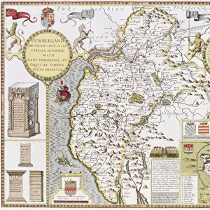
Map Tractus regni Angliae septentrion quo ducatus Eboracensis

![]()
Wall Art and Photo Gifts from Liszt Collection
Map Tractus regni Angliae septentrion quo ducatus Eboracensis
Map, Tractus regni Angliae septentrion. in quo ducatus Eboracensis, episcopatus Dunelmensis, comitatus Northumbriae, Cumbriae, Westmoriae, et Lancastriae cum Mona insula, Frederick de Wit (1610-1698), Copperplate print
Liszt Collection of nineteenth-century engravings and images to browse and enjoy
Media ID 19585260
© Artokoloro
1610 1698 Copperplate Print Frederick De Wit
FEATURES IN THESE COLLECTIONS
> Arts
> Artists
> W
> Frederick de Wit
> Maps and Charts
> Related Images
EDITORS COMMENTS
This print showcases the exquisite "Map Tractus regni Angliae septentrion quo ducatus Eboracensis" by Frederick de Wit. Crafted with meticulous detail, this copperplate print transports us back to a time when cartography was both an art form and a scientific endeavor. The map depicts the northern region of England, encompassing the Duchy of York, Durham Bishopric, Northumbria County, Cumbria County, Westmorland County, Lancashire County along with Mona Island. Its intricate lines and delicate shading beautifully illustrate the topography of these historic territories. Frederick de Wit's expertise in mapmaking is evident in every stroke. The precision and accuracy he employed are truly remarkable considering this masterpiece was created during the 17th century. As we gaze upon this piece of history preserved through time, we can't help but marvel at De Wit's skillful craftsmanship. Beyond its artistic value lies a wealth of historical information waiting to be discovered. This print offers a window into England's past - an era defined by feudalism and regional divisions that shaped the nation as we know it today. Whether you are an avid collector or simply appreciate fine artistry and historical significance, this print from Liszt Collection is sure to captivate your imagination. It serves as a testament to human ingenuity and reminds us how maps have guided our exploration for centuries.
MADE IN THE USA
Safe Shipping with 30 Day Money Back Guarantee
FREE PERSONALISATION*
We are proud to offer a range of customisation features including Personalised Captions, Color Filters and Picture Zoom Tools
SECURE PAYMENTS
We happily accept a wide range of payment options so you can pay for the things you need in the way that is most convenient for you
* Options may vary by product and licensing agreement. Zoomed Pictures can be adjusted in the Cart.