Home > Europe > United Kingdom > England > London > Sights > St James Park
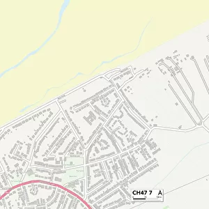
Wirral CH49 2 Map

![]()
Wall Art and Photo Gifts from Map Marketing
Wirral CH49 2 Map
Postcode Sector Map of Wirral CH49 2
Media ID 19967586
Broadway Bromsgrove Road Brookdale Close Brookside Drive Ch49 Duncan Drive Eastway Greenway Harvester Way Hazelwood Highfield Drive Holcombe Close Ingleton Close Kirkway Longfield Close Malmesbury Close Norwood Road Pump Lane Shepherd Close St James Close Stable Close Westway Willow Park Wirral Wood Lane Woodway
FEATURES IN THESE COLLECTIONS
> Arts
> Artists
> W
> James Wood
> Europe
> United Kingdom
> England
> London
> Sights
> St James Park
> Map Marketing
> Postcode Sector Maps
> CH - Chester
> Maps and Charts
> Related Images
MADE IN THE USA
Safe Shipping with 30 Day Money Back Guarantee
FREE PERSONALISATION*
We are proud to offer a range of customisation features including Personalised Captions, Color Filters and Picture Zoom Tools
SECURE PAYMENTS
We happily accept a wide range of payment options so you can pay for the things you need in the way that is most convenient for you
* Options may vary by product and licensing agreement. Zoomed Pictures can be adjusted in the Cart.