Home > Animals > Birds > Gruiformes > Rallidae > Red Rail
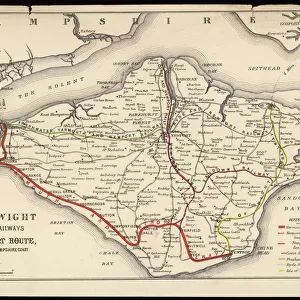
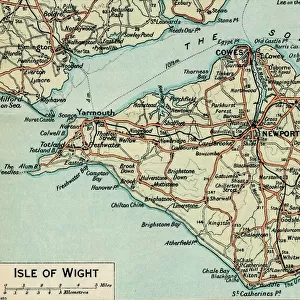
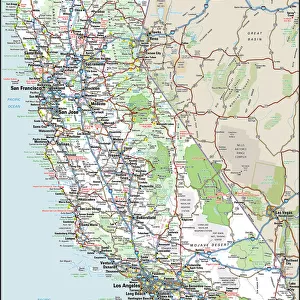
Map of the Isle of Wight

![]()
Wall Art and Photo Gifts from Mary Evans Picture Library
Map of the Isle of Wight
Map of the Isle of Wight, showing the principal roads (marked in red) and the internal Island rail network Date: 1910
Mary Evans Picture Library makes available wonderful images created for people to enjoy over the centuries
Media ID 7195697
© Mary Evans Picture Library 2015 - https://copyrighthub.org/s0/hub1/creation/maryevans/MaryEvansPictureID/10508822
FEATURES IN THESE COLLECTIONS
> Animals
> Birds
> Gruiformes
> Rallidae
> Red Rail
> Maps and Charts
> Related Images
EDITORS COMMENTS
1. Title: A Journey Through Time: The Isle of Wight's Road and Rail Network in 1910. Step back in time with this map print of the Isle of Wight, showcasing the principal roads and the internal Island rail network as they appeared in 1910. This intriguing snapshot of history transports us to an era when horse-drawn carriages shared the roads with the first automobiles, and steam trains connected the coastal communities of this picturesque British isle. The map, dating back to 1910, offers a unique perspective on the Isle of Wight's transportation infrastructure during a pivotal moment in its history. The roads, marked in bold red lines, crisscross the island, revealing the main routes that connected its various towns and villages. The intricate rail network, also depicted in red, weaves its way through the landscape, providing a glimpse into the island's industrial past and the role it played in shaping its modern transportation system. The Isle of Wight, located off the south coast of England, has long been a popular destination for visitors seeking a respite from the hustle and bustle of urban life. This map serves as a testament to the island's rich history and its commitment to progress. It invites us to explore the island's charming towns, beautiful beaches, and stunning landscapes, all while immersing ourselves in the stories of the past that continue to shape its unique character. This map print, with its intricate details and captivating historical context, makes for an excellent addition to any home or office. It is not only a beautiful piece of decor but also an educational tool that allows us to appreciate the evolution of transportation on the Isle of Wight and the broader impact it had on the island's development. So, take a journey through time with this map print and discover the fascinating history of the Isle of Wight's road and rail network in 1910.
MADE IN THE USA
Safe Shipping with 30 Day Money Back Guarantee
FREE PERSONALISATION*
We are proud to offer a range of customisation features including Personalised Captions, Color Filters and Picture Zoom Tools
SECURE PAYMENTS
We happily accept a wide range of payment options so you can pay for the things you need in the way that is most convenient for you
* Options may vary by product and licensing agreement. Zoomed Pictures can be adjusted in the Cart.