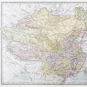
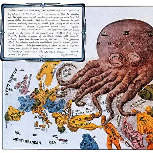
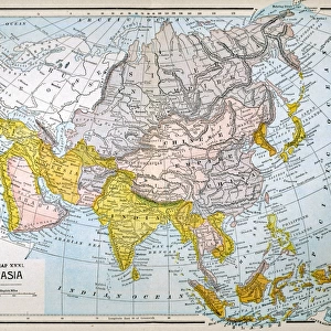
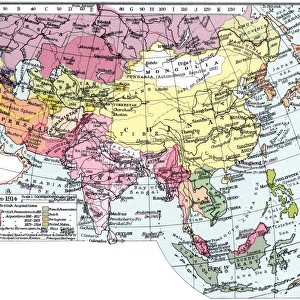
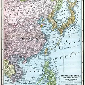
Train routes through Eastern Asia

![]()
Wall Art and Photo Gifts from Mary Evans Picture Library
Train routes through Eastern Asia
Train routes through Eastern Asia operated by the South Manchurian Railway Co. Date: circa 1905
Mary Evans Picture Library makes available wonderful images created for people to enjoy over the centuries
Media ID 7245453
© Mary Evans Picture Library 2015 - https://copyrighthub.org/s0/hub1/creation/maryevans/MaryEvansPictureID/10578997
Korea Manchuria Manchurian Mongolia Routes
EDITORS COMMENTS
This vintage map print depicts the extensive train routes through Eastern Asia, specifically in the regions of China, Japan, Korea, Mongolia, and Manchuria, during the early 1900s. The intricate network of railways was primarily operated by the South Manchurian Railway Company, which played a significant role in connecting these countries and transforming transportation in the region. The map showcases the extensive reach of the railway system, with numerous lines crisscrossing the landscape, connecting major cities and towns. The South Manchurian Railway Company's influence is particularly evident in the heavily populated areas of Manchuria, where the railway lines form a dense web. The map also highlights the international scope of the railway network, with lines extending from China's eastern coast into the heart of Manchuria, and from the Korean peninsula into Japan's northern island of Hokkaido. The railway lines also extend into Mongolia, further underscoring the company's far-reaching influence. The intricate details of the map reveal the meticulous planning and engineering that went into building the railway system. The various train routes are labeled in English and Japanese, reflecting the multinational nature of the railway company and the region as a whole. This map offers a fascinating glimpse into the past, providing insights into the historical transportation landscape of Eastern Asia during a time of significant change and growth. It is a testament to the power of infrastructure to connect people and countries, and to facilitate the exchange of goods, ideas, and cultures.
MADE IN THE USA
Safe Shipping with 30 Day Money Back Guarantee
FREE PERSONALISATION*
We are proud to offer a range of customisation features including Personalised Captions, Color Filters and Picture Zoom Tools
SECURE PAYMENTS
We happily accept a wide range of payment options so you can pay for the things you need in the way that is most convenient for you
* Options may vary by product and licensing agreement. Zoomed Pictures can be adjusted in the Cart.