Home > Europe > United Kingdom > England > Kent > Gillingham
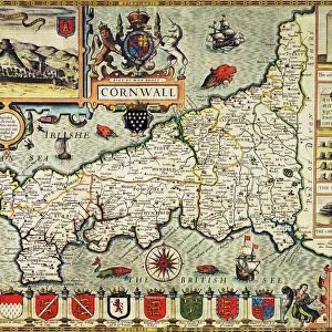
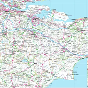
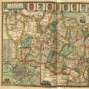
John Speeds map of Kent, 1611

![]()
Wall Art and Photo Gifts from Sheffield City Archives
John Speeds map of Kent, 1611
Image from Theatre of the Empire of Great Britaine presenting an exact geography of the Kingdomes of Ireland, Scotland, Ireland, and the Iles adioyning with The Shires, Hundreds, Cities and Shire Towns, within ye Kingdome of England, divided and described by John Speed (original at Sheffield Libraries: 914.2 SQ).
Note these images are from 400-year-old maps from a tightly bound volume. They show some wear and tear as well as the binding in the middle of the image
Sheffield City Archives and Local Studies Library has an unrivalled collection of images of Sheffield, England
Media ID 26388872
© Sheffield City Council - All Rights Reserved
Ashford Canterbury Chatham Dartford Dover Folkestone Gillingham Gravesend John Speed Maidstone Margate Ramsgate Rochester Sevenoaks Tunbridge Wells
FEATURES IN THESE COLLECTIONS
> Arts
> Artists
> S
> John Speed
> Europe
> Republic of Ireland
> Maps
> Europe
> United Kingdom
> England
> Canterbury
> Europe
> United Kingdom
> England
> Kent
> Ashford
> Europe
> United Kingdom
> England
> Kent
> Canterbury
> Europe
> United Kingdom
> England
> Kent
> Chatham
> Europe
> United Kingdom
> England
> Kent
> Dartford
> Europe
> United Kingdom
> England
> Kent
> Dover
> Europe
> United Kingdom
> England
> Kent
> Folkestone
> Europe
> United Kingdom
> England
> Kent
> Gillingham
> Sheffield City Archives
> Maps and Plans
> John Speed's County Maps, 1611
EDITORS COMMENTS
This print showcases John Speed's map of Kent from 1611, a remarkable piece of cartographic history. The image is extracted from the renowned "Theatre of the Empire of Great Britaine" an extensive work that provides a precise geography of England, Scotland, Ireland, and their surrounding islands. Despite its age, this 400-year-old map bears witness to the wear and tear it has endured over time. The signs of aging are evident in its delicate features and slight imperfections caused by years of use and handling. Additionally, due to its placement within a tightly bound volume, the binding can be seen running through the middle portion of the image. As we explore this vintage depiction of Kent County, we encounter various notable locations such as Maidstone, Gillingham, Dartford, Chatham, Ashford, Rochester, Margate, Gravesend Canterbury Dover Tunbridge Wells Ramsgate Sevenoaks Folkestone - each marked with precision on Speed's intricate creation. It is important to note that these images are presented solely for historical purposes and not intended for commercial use. They serve as a testament to John Speed's exceptional craftsmanship in mapping out England's regions during his time. Thanks to Sheffield Libraries' collection at Sheffield City Archives (914.2 SQ), we have been granted access to this invaluable snapshot from our past – an opportunity to appreciate both artistry and historical significance intertwined within one extraordinary piece.
MADE IN THE USA
Safe Shipping with 30 Day Money Back Guarantee
FREE PERSONALISATION*
We are proud to offer a range of customisation features including Personalised Captions, Color Filters and Picture Zoom Tools
SECURE PAYMENTS
We happily accept a wide range of payment options so you can pay for the things you need in the way that is most convenient for you
* Options may vary by product and licensing agreement. Zoomed Pictures can be adjusted in the Cart.